
I. Geographic Crucible: Asia’s Pivotal Endorheic Artery
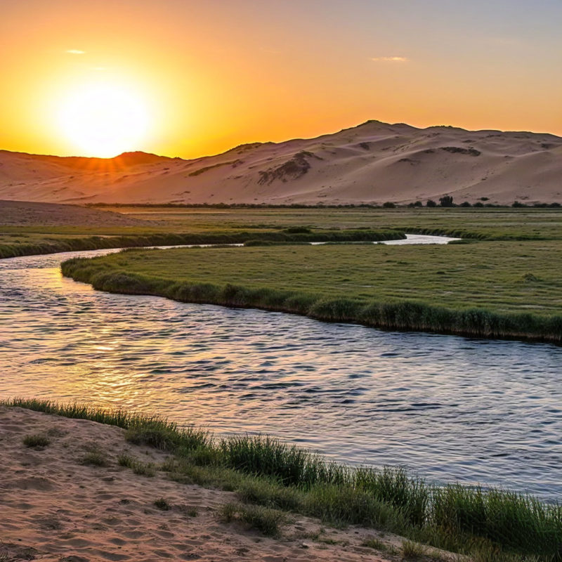
Flowing relentlessly through the Taklamakan Desert – Earth’s second-largest shifting-sand desert – the Tarim River traverses 1,321 kilometers across northwestern China, anchoring the largest inland river basin in the country encompassing over 1 million square kilometers. Its watershed extends from the Kunlun-Pamir knot where tectonic collisions birth glaciers sustaining continental hydrology, descending through hyper-arid basins receiving merely 50 millimeters of annual precipitation yet nurturing oasis civilizations for millennia. The river’s terminal Lop Nor depression historically functioned as a migratory corridor for Eurasian species, while its deltaic fingers create dynamic wetlands that paradoxically flourish amidst surrounding dunes exceeding 300 meters in height. This endorheic system (internally draining rather than reaching the sea) epitomizes the delicate equilibrium between glacial meltwater reserves and evaporative demand in Central Asia’s rain-shadow deserts, where every cubic meter of flow represents a calculated ecological negotiation.
II. Hydrological Anatomy: Sources, Fluxes, and Disappearing Acts
IN. Triple-Fed Headwaters
The Tarim’s flow originates from three primary tributaries exhibiting distinct hydrological personalities:
- Yarkand River: Glacier-dominated (73% glacial melt contribution) with peak discharge in July-August from the Karakoram Range, transporting mineral-rich sediments that fertilize the Yarkand Oasis
- Hotan River: Exhibits violent glacial outburst floods known locally as kök-boroon (blue storms), carrying jade particles from Kunlun Mountains that historically financed Silk Road kingdoms
- Aksu River: Groundwater-sustained baseflow (42% of dry-season volume) from the Tian Shan limestone aquifers, demonstrating remarkable interannual stability despite climate perturbations
B. Ephemeral Hydrology
Modern gauging stations reveal alarming flow attenuation:
- Upper Basin (Aral Section): Maintains 80-90% of historic discharge (3.4 billion m³/year)
- Middle Basin (Daxihaizi Reservoir): Flow diminishes to 45% due to agricultural diversions supporting 85% of Xinjiang’s cotton output
- Lower Basin (Taitema Lake): Receives merely 7-12% of total headwaters, transforming this terminal lake into an episodic feature that vanishes for years before emergency water releases
III. Ecosystems of Extremes: Biodiversity in Arid Landscapes
IN. Riparian Refugees
Along desiccated channels, phreatophytic vegetation develops extraordinary survival adaptations:
- Tarim Poplar (Populus euphratica): Develops dual root systems – surface roots capturing ephemeral floods and taproots plunging 28 meters to access saline aquifers
- Tamarix ramosissima: Excretes salt crystals through leaf glands at rates exceeding 500 kg/ha annually, creating visible evaporite halos around stems
- Apocynum venetum: Produces industrial-grade bast fibers within xylem tissues to withstand -30°C to 50°C thermal oscillations
B. Faunal Resilience
Critically endangered species cling to fragmented habitats:
| Species | Adaptation | Conservation Status |
|---|---|---|
| Wild Bactrian Camel | Blood plasma hypersomotic regulation | IUCN Critically Endangered |
| Tarim Red Deer | Nocturnal water-mining behaviors | Regional Extinction |
| Lop Nor Scorpionfish | Urea retention for osmoregulation | Data Deficient |
Iv. Human Mosaics: 2,000 Years of Oasis Civilizations
IN. Silk Road Hydraulic States
Ancient kingdoms engineered sophisticated water allocation systems:
- Kroraina (Loulan) Civilization: Developed qanat-inspired subterranean channels (karez) reducing evaporation by 92% compared to surface canals
- Khotan Kingdom: Instituted the “Mirab” – state-appointed water masters who allocated flow via ceramic clepsydra timers during peak growing seasons
- Kucha Federation: Constructed sediment-settling basins using woven tamarisk filters, achieving 80% silt removal efficiency
B. Contemporary Demographic Pressures
Modern settlement patterns intensify water stress:
- Agricultural Colonies: 12 million mu (800,000 hectares) of cotton fields consuming 18 billion m³/year – equivalent to 75% of the Tarim’s natural flow
- Petrochemical Cities (Korla): Coal-to-chemical industries withdrawing 3.8 million m³/day from Cretaceous aquifers, causing regional water table declines of 2.1 meters/year
- Strategic Resettlement Programs: Han migration increased basin population by 48% since 2000, escalating domestic water demand beyond aquifer recharge capacity
V. Converging Crises: Climate Change and Hydropolitical Tensions
IN. Glacial Recession Metrics
Satellite gravimetry confirms alarming ice mass depletion:
- Tomur Glacier: Retreated 340 meters vertically since 1990, reducing meltwater contribution by 19%
- Muztagh Ata Ice Cap: Thinning at 0.7 meters/year, diminishing the Yarkand’s baseflow
- Kunlun Snowline: Ascended 216 meters elevation since 1950, shrinking the cryosphere contribution from 38% to 29% of basin inflow
B. Transboundary Water Governance
Upstream developments threaten downstream ecologies:
- Kyrgyzstan’s Kambarata Dams: Potential diversion of 15% of Naryn River headwaters feeding the Tarim
- Tajikistan’s Rogun Reservoir: Will impound 13.3 km³ of Vakhsh River waters that historically recharged Pamir aquifers feeding the Yarkand
- China’s Water Diversion Projects: South-North Water Transfer’s Western Route proposes extraction of 8 billion m³/year from upper Tarim tributaries
Vi. Engineering Survival: Restoration Technologies and Policies
IN. Ecological Water Transfers (EWT)
Since 2000, China has implemented emergency flood releases to revive terminal ecosystems:
- 2017-2022 Mega-Releases: 3.5 billion m³ discharged downstream, reconnecting the river to Taitema Lake for 1,128 consecutive days – the longest sustained flow since 1972
- Vegetation Response: Populus euphratica forests expanded by 215 km² along the lower reaches, confirmed by NASA MODIS NDVI analysis
- Sand Fixation: Aeolian sediment transport decreased by 27 megatons/year along rewatered corridors
II. Precision Agricultural Reformation
Industrial farming innovations reduce irrigation waste:
- Plastic Mulch Micro-Drip Systems: Cut cotton water requirements from 8,000 m³/ha to 5,200 m³/ha while increasing yields by 30%
- Phytoremediation Buffers: Salt-accumulating Suaeda salsa plantations along drainage canals intercept 14 tons/ha/year of agricultural salinity
- Cloud-Seeding Enhancements: Tibetan Plateau weather modification increased snowfall by 12% over headwaters during 2018-2024
The Tarim’s future hinges on integrated basin governance that recalibrates human demands within biophysical thresholds – a hydrological tightrope walk where failure means surrendering another 1,000 kilometers of river to the Taklamakan’s dunes. As China advances its “Ecological Civilization” paradigm, this desert artery tests whether technological interventions can outpace environmental debt in our century of scarcity.